

Nossos serviços estão apresentando instabilidade no momento. Algumas informações podem não estar disponíveis.
-
Home

-
Geosciences
-
Maps
-
Brazil: Geographic networks
- NP-Novo Portal
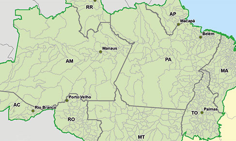
Legal Amazon
Description
The Legal Amazon corresponds to the area under the responsibility of the Superintendence of the Amazon Development – SUDAM established by Article 2 of Complementary Law no. 124, of 03/01/2007. The region is formed by the states of Acre, Amapá, Amazonas, Pará, Rondônia, Roraima, Tocantins and Mato Grosso, and also by the municipalities of the state of Maranhão located west of the 44th meridian. It has an approximate area of 5 217 423 km², which corresponds to about 61% of the Brazilian territory.
About the publication - 2024
This publication includes the limits of the Legal Amazon, municipal limits and the positions of the headquarters of the municipalities that make up the Legal Amazon, as well as attributes that characterize how these municipalities and headquarters interact with the region.
This publication is the result of geoprocessing operations carried out based on the 2024 Municipal Digital Mesh, available at the following address: https://www.ibge.gov.br/geoCiencias/organização-do-territorio/malhas-territorials/15774-malhas.html?=&t=acesso-ao-produto
Therefore, this publication inherits all the characteristics and conditions of use associated with the 2024 Municipal Digital Mesh. For more details, access the Technical Note: https://biblioteca.ibge.gov.br/index.php/biblioteca-catalogo?view=detalhes&id=2102169
This publication consists of three geospatial files in SHP format and one spreadsheet in XLS and ODS format containing only the attributes and two versions of PDF maps:
Limites_Amazonia_ Legal_ 2024: It is the representation of the limits of the Legal Amazon, composed of one polygon. Presents the following attributes:
- NOME: “Legal Amazon”
- AREA_KM2: informs the area in square kilometers
Sedes_Mun_Amazonia_Legal_ 2024: it is the representation of the points that represent the municipal headquarters of each municipality of the region. It consists of 773 points. Presents the following attributes:
- NM_REGIAO: informs the name of the geographic area to which the municipality belongs.
- CD_UF: Numeric code associated by the IBGE to the State to which the Municipality belongs.
- NM_UF: Name of the State to which the municipality belongs.
- SIGLA_UF: Acronym of the State to which the municipality belongs.
- CD_MUN: Numerical code associated by the IBGE to the municipality.
- NM_MUN: Name of the Municipality.
- LAT_SEDE: Latitude coordinate expressed in decimal degrees.
- LNG_SEDE: Longitude coordinate expressed in decimal degrees.
- SEDE_AL: Informs whether the municipal headquarters is located inside (“yes”) or outside (“no”) of the Legal Amazon.
Mun_Amazonia_Legal_2024: It is the representation of the polygons of the municipalities that are part of the Legal Amazon. The 772 municipalities include 874 polygons due to the subordination of some islands. Presents the following attributes:
- CD_MUN: Municipality Code
- NM_MUN: Name of the Municipality
- CD_RGI: Code of the Immediate Region
- NM_RGI: Name of the Immediate Region
- CD_RGINT: Code of the Intermediate Region
- NM_RGINT: Name of the Intermediate Region
- CD_UF: Code of the Federation Unit (state)
- NM_UF: Name of the Federation Unit (state)
- SIGLA_UF: Acronym of the Federation Unit (state)
- CD_REGIAO: Code of the Region
- NM_RG: Name of the Region
- SIGLA_RG: Acronym of the Region
- AREA_TOT: Total area of the municipality expressed in square kilometers.
- AREA_INT: Municipality area within the Legal Amazon, expressed in square kilometers.
- PORC_INT: Percentage of the area of the municipality that is within the area of the Legal Amazon, expressed in percentage (0 - 100%)
More on the product - 2024
Learn more - 2024
News and Releases
IBGE releases updating of legal territorial divisions of Brazil
The IBGE releases today (14) an updating of the legal territorial divisions of Brazil. Altogether, they...
14/07/2022
IBGE updates municipal borders in Legal Amazon Map
The IBGE releases today (June 16) the 2020 Legal Amazon Map, based on the update of the Municipal Mesh....
16/06/2021
Errata
Replacement of Map, in PDF, of product "Legal Amazon"
Published date: 23/07/2025
Description:
Replacement of the Map, in PDF, of product "Legal Amazon", due to the inversion of the initials of the states of Mato Grosso (MT) and Mato Grosso do Sul (MS) and omission of the initials of the state of Acre (AC).
Note: The failure with the initials of the states did not compromise the vector files of limits, the respective territorial areas and the positions of the seats of the municipalities or any other geoprocessing operations inherent to these products.Actions: The file has been amended and replaced.
Links
SUDAM - http://www.sudam.gov.br/
FAQ
Is the IBGE responsible for the Legal Amazon delimitation?
No. The Legal Amazon was established by Law and the Superintendence of the Amazon Development – SUDAM is responsible for any alteration in its limits.
Why does the IBGE release the Legal Amazon as a geographic subdivision?
The IBGE's aim is to release geographic subdivisions that are relevant for statistical dissemination, planning and for public and private investment. The main objective is the identification of Brazil's political administrative units located in the area defined as Legal Amazon, which require specific management due to their climatic characteristics.
Which is the frequency of Legal Amazon updating?
Legal Amazon, as a legal subdivision, will only have its delimitation updated when there is a legislative or normative update of these subdivisions. There may be updates related to the Territorial Division of Brazil that can impact on the states and municipalities limits and nomenclature.
Where can I obtain more information about the Legal Amazon?
It is possible to get more information on the SUDAM website (http://www.sudam.gov.br/), or from studies released by the IBGE, such as the Natural Resources Geostatistics of the Legal Amazon (https://biblioteca.ibge.gov.br/index.php/biblioteca-catalogo?view=detalhes&id=249694).
What are the legislations regarding the Legal Amazon?
The legislations can be consulted on the SUDAM website (http://www.sudam.gov.br/index.php/quem-e-quem/58-acesso-a-informacao/86-legislacao-da-amazonia).
Your question was not answered here?
Please contact us through our service channels.
Saiba mais
Background
The term Legal Amazon was only incorporated in the most recent legislation, such as Law no. 11,952, of June 25, 2009, and the Forestry Code (Law no. 12,651, of May 25, 2012), and it is not explicitly included in the laws that established the Brazilian Amazon area for the purpose of public policies in the previous decades. The use of the adjective "legal" is to distinguish the division of the Amazon region by biome or river basin established by legislation, as well as of the International Amazon. According to Art. 43 of the Federal Constitution, the Union is in charge of creating the Legal Amazon and can articulate its action in the same social and geoeconomic complex, aiming at its development and at the reduction of regional inequalities. For that matter, the Legal Amazon was established aiming at defining the geographic delimitation of the political region that will attract tax incentives to foster its regional development.
The Legal Amazon is divided into two parts: Western Amazon, comprising the states of Amazonas, Acre, Rondônia and Roraima, and Eastern Amazon, comprising the states of Pará, Maranhão, Amapá, Tocantins and Mato Grosso. The Western Amazon was mentioned for the first time in Decree-Law no. 291, of February 28, 1967, and ratified in Decree-Law no. 356, of August 15, 1968.
The establishment of the Brazilian Amazon area was always associated to the creation of public offices and the implementation of governmental policies. The first definition dates back to 1953, made by Law no. 1,806, of January 6, 1953, which created the Superintendence of the Economic Valorization Plan of the Amazon - SPVEA and established its action area, encompassing the regions comprising the states of Pará and Amazonas, the federal territories of Acre, Amapá, Guaporé and Rio Branco, and also part of the state of Mato Grosso to the north of Parallel 16, part of the state of Goiás to the north of Parallel 13 and part of Maranhão to the west of Meridian 44. It was a geopolitical construction aiming at establishing an area to apply economic and territorial policies to incorporate the north vastness of the Brazilian territory into the socioeconomic fabric, thus assuring the sovereignty over the territory.
In the 1960s, changes in the Brazilian territorial planning led to the extinction of SPVEA and its replacement by the Superintendence for Development of the Amazon - SUDAM, which became in charge of running the Economic Valorization Plan of the Amazon. Nevertheless, the redaction of Law no. 5,173, of October 27, 1966, maintained the Amazon area established by Law no. 1,806, of January 6, 1953.
The Amazon area and, consequently, the action area of SUDAM remained unchanged until 1977, when the state of Mato Grosso do Sul was created. The Complementary Law no. 31, of October 11 1977, extended the border of Amazon beyond Parallel 16, matching the border of the states of Mato Grosso and Mato Grosso do Sul. The limits of the Legal Amazon were not changed with the enactment of the Federal Constitution, which created the state of Tocantins. Those limits were only changed in 2001, when the Provisional Measure no. 2,146-1, of May 4, 2001, extinguished SUDAM and created the Amazon Development Agency - ADA. The limit represented by Parallel 13, in force up to then, was replaced by the border of the states of Goiás and Tocantins. The same redaction was given by Provisional Measure no. 2,157-5, of August 24, 2001. The Complementary Law no. 124, of January 3, 2007, which recreated SUDAM, established as its action area exactly the same defined by Provisional Measures no. 2,146-1 and no. 2,157-5, of 2001.
Legislação relacionada
-
- Law no. 1,806, of January 6, 1953
Article 2 For the purpose of economic planning and accomplishment of the plan established in this law, the Brazilian Amazon encompasses the region comprising the States of Pará and Amazonas and the federal territories of Acre, Amapá, Guaporé and Rio Branco, as well as part of the State of Mato Grosso to the north of parallel 16o, part of the State of Goiás to the north of parallel 13o and part of the State of Maranhão to the west of meridian 44o. - Law no. 5,173, of October 27, 1966
Article 2 For the purposes of this law, the Amazon encompasses the region comprising the States of Acre, Pará and Amazonas and the Federal Territories of Amapá, Roraima and Rondônia, as well as the areas of the State of Mato Grosso to the north of parallel 16o, of the State of Goiás to the north of parallel 13o and of the State of Maranhão to the west of meridian 44o. - Complementary Law no. 21, of October 11, 1977
Article 45 The Amazon, referred in article 2 of Law no. 5,173, of October 27, 1966, will also encompass the entire area of the State of Mato Grosso. - Provisional Measure no. 2,146-1, of May 4, 2001
Creates the Agencies for the Development of Amazon and of the Northeast, extinguishes the Superintendence for the Development of Amazon (SUDAM) and the Superintendence for the Development of the Northeast (SUDENE), and sets forth other provisions. - Complementary Law no. 124, of January 3, 2007
Establishes, in the form of article 43 of the Federal Constitution, the Superintendence for the Development of Amazon (SUDAM); establishes its composition, legal nature, objectives, area of competence and instruments of action; rules on the Fund for the Development of Amazon (FDA); changes Provisional Measure no. 2,157-5, of August 24, 2001; revokes Complementary Law no. 67, of June 13, 1991; and sets forth other provisions.
- Law no. 1,806, of January 6, 1953
