

Nossos serviços estão apresentando instabilidade no momento. Algumas informações podem não estar disponíveis.
-
Home

-
Geosciences
-
Geodetic positioning
-
Services for geodetic positioning
- NP-Model for converting geometric altitudes (given by GNSS) into physical altitudes (compatible with the SGB´s Vertical Datum)
Model for converting geometric altitudes (given by GNSS) into physical altitudes (compatible with the SGB´s Vertical Datum)
Description
Digital model that provides the factors to convert altitudes given by GNSS receivers, resulting in altitudes compatible with the terrestrial gravity, more suitable to describe the flow of liquid masses, like those needed in large irrigation projects, hydroelectric generation, etc.
In technical terms, a model to convert altitudes numerically describes the separation between the ellipsoid of reference of the geometric altitudes - also called ellipsoidal, resulting from the use of Global Navigation Satellite Systems (GNSS) - and the surface of reference of the physical altitudes, which is the vertical datum of the High-Precision Altimetric Network (RAAP) of the Brazilian Geodetic System (SGB), in the case of Brazil. From the geodetic coordinates resulting from the suitable processing of the observations collected through a geodetic GNSS receiver, the factor to convert geometric altitudes into physical altitudes should be extracted from the model.
The first models to convert altitudes published by the IBGE where the geoid models of the MAPGEO series, produced in partnership with the University of São Paulo (USP). MAPGEO92, MAPGEO2004, MAPGEO2010 and MAPGEO2015. The last one was the basis to develop the most recent model, hgeoHNOR2020, which opens a new series of models characterized by a better adaptation to the altitudes present in RAAP.
Technical Information
As responsible for the Brazilian Geodetic System (SGB), the IBGE publicly releases the geodetic information of reference required for a precise spatial positioning. In the case of the applications involving vertical positioning - like the feasibility studies and implementation works of large hydroelectric endeavors or the activities of prevention and monitoring of coastal floods associated with the rise of the average sea level due to global warmth -, the basic information is the altitude associated with each one of the nearly 70 thousand Level References (RRNN) established by the IBGE since 1945 along the entire national road network.
Such altitudes are tightly coupled with the terrestrial gravity field, assured with the use of specific observation methodologies, associating gravimetric information (either observed or theoretical) with the gaps resulting from the traditional technique of geometric leveling with procedures and instruments specifically designed for high precision. Today, the altitudes obtained that way are generically named physical altitudes. In Brazil, those altitudes were known as orthometric-normal until July 2018, when the new adjustment of the so-called High-Precision Altimetric Network (RAAP) resulted in the so-called normal altitudes, improving the integration in relation to the terrestrial gravity field.
On the other hand, the increasing adoption of positioning solutions via satellite systems led to a higher availability of another type of altitude, completely apart from the gravity field - the geometric altitude. Following up the need to convert those geometric altitudes into orthometric-normal altitudes, the demand for the so-called geoid undulation models stepped up. They represent the separation between the respective surfaces of reference (ellipsoid and geoid), named undulation or, preferably, geoid height. In Brazil, the initial versions of those models looked like geoid maps, produced and assessed from RRNNs matching the first geodetic stations established with spatial techniques - the SAT Doppler stations, resulting from observation of the Transit satellites. Compared with the results currently obtained with positioning systems via satellites, the altitudes obtained from the Transit system had significantly higher uncertainties, reaching several meters. Therefore, the consequences that the physical altitudes of the SGB were not strictly orthometric, but rather orthometric-normal, were insignificant - a proxy of the original concept in the case of unavailability of gravimetric observations in the work region.
With the improvement of the quality of the geometric altitudes obtained by common users, resulting from the evolution of the infrastructure associated with the Global Navigation Satellite Systems (GNSS), the biggest uncertainties in the conversion between altitudes began to be attributed to the geoid undulation model itself, mainly due to the impossibility to reach a dense and homogeneous gravimetric coverage in the entire National Territory and along a reasonable border and coastal line. In addition, the difference between the strict concept of orthometric altitude and its proxy through normal-orthometric altitudes of the SGB´s altimetric network became more significant.
Therefore, the IBGE began to carry out exclusive campaigns of GNSS in RRNNs in 2008, stepping them up from 2015 onwards. As a result, it was possible to recently hit a minimally suitable distribution of the so-called SAT-RN stations to begin the studies related to the improvement of the conversion of altitudes.
Lastly, it should be highlighted that the improvement of the model of conversion of altitudes was also boosted by the release of the new normal altitudes, resulting from the Adjustment of the Altimetric Network with Geo-potential Numbers (REALT-2018). Besides better coupling with the terrestrial gravity field, that new set of altitudes also reflects the effects of an extensive debugging of the gaps of the entire altimetric network. In order to also benefit the GNSS users, a specific model to convert altitudes was required, reinforcing the reasons to develop the hgeoHNOR2020. Details of that development are presented in the respective report.
About the publication - hgeoHNOR2020
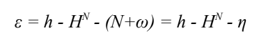
The hgeoHNOR2020 model provides the separation between the ellipsoid of reference of the geometric altitudes in SIRGAS2000 and the surfaces of reference of the REALT-2018 implementation of the vertical component of the Brazilian Geodetic System (SGB), i.e., the vertical data of Imbituba and Santana. Therefore, the factor for conversion extracted from the (η) model allows to obtain the modeled normal altitudes (HNmod), compatible with REALT-2018, from geometric altitudes (h) resulting from GNSS measurements in regions where there is no suitable coverage of the High-Precision Altimetric Network (RAAP), i.e., where there are no altimetric stations of the SGB:
HNmod = h - η
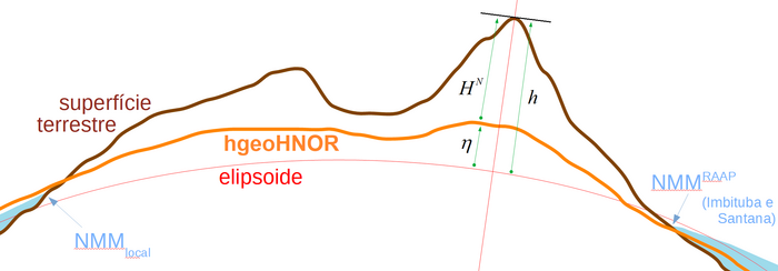
It should be highlighted that, in spite of the current physical altitudes of RAAP are of the normal type, their surface of reference cannot be considered equivalent to the global near-geoid, since the values of reference of the vertical data of Imbituba and Santana were maintained.
Likewise, the hgeoHNOR2020 model cannot be considered a gravimetric model of the near-geoid, not only due to the previous particularity, but also due to the fact that conventional methodologies have not been used to model the gravity field. hgeoHNOR2020 was calculated by means of the Least Squares Adjustment (CMQ) from residues of the geoid heights, extracted from MAPGEO2015, in relation to the differences between the normal and geometric altitudes in the SAT-RN stations.
Therefore, the model absorbs all the inherent characteristics of those three information sources, including the different compositions of errors, strategies of treatment of the permanent tide, etc., and cannot be associated with the near-geoid. In addition, possible changes in the position of the stations in the period between the two types of surveying (leveling and GNSS) can affect that type of geometric modeling.
In order to express that difference, the conversion factor η, provided by hgeoHNOR2020, should be considered as the addition of those inherent influences (Δ) to the separation values between the global near-geoid and the ellipsoid (ζ, altitude anomalies): η = ζ + Δ.
The access to the model is made through a calculation service implemented in this portal, streamlining the acquisition of the factors to convert between h and HN and respective uncertainties. The entry data are directly submitted through the keyboard - with the result immediately shown on the screen - or, preferably, through a file containing the list of coordinates. In this case, the results are sent to the electronic address informed, in three types of format (.txt, .csv and .kml). The direct communication with the online service to post-process GNSS data (IBGE-PPP) was also implemented in that calculation service, also available on this portal, allowing the PPP results to remain consistent with the model to convert altitudes.
Only the points located in the National Territory are submitted to the processes to select the relevant grids and interpolate the respective magnitudes through bi-cubic spline. The performance of the calculation service is mainly conditioned by two factors: previous checking of the polygons (national limits, Santana area and MAPGEO2015 west area) and the interpolation itself. For the points within the national limits, the performance is nearly 0.46 ms/point (nearly 130,000 points/min), being 60% of this time consumed in the interpolation.
More on the product - hgeoHNOR2020
The access to the hgeoHNOR2020 model is through the respective online calculation service or through calculation, to be carried out by the users themselves, by including the grids and other information in “downloads”
Publications - hgeoHNOR2020
Modelo hgeoHNOR2020 para conversão de altitudes geométricas em altitudes normais / IBGE, Coordenação de Geodésia
Material type: Book
Year: 2021
Learn more - hgeoHNOR2020
Background
The altitudes of the Level References (RRNNs) of the High-Precision Altimetric Network (RAAP) of the Brazilian Geodetic System (SGB) are characterized by a tight coupling with the terrestrial gravity field. They are currently called physical altitudes, according to the conceptual notes introducing the new specifications and norms for geodetic surveyings associated with the Brazilian Geodetic System, though they were traditionally known as orthometric altitudes by producers and users of geospatial information.
On the other hand, the growing adoption of positioning solutions through satellite systems by that community, based on the consolidation of the Global Positioning System (GPS) and the emergence of international services to improve their respective inputs, led to the availability of another type of altitude, entirely decoupled from the gravity field - the geometric altitude. Following up the need to convert those geometric altitudes into orthometric altitudes, the demand for the so-called geoid undulation models stepped up. They represent the separation between the respective surfaces of reference (ellipsoid and geoid), named undulation or, preferably, geoid height. In Brazil, the initial versions of those models looked like geoid maps, produced and assessed from RRNNs matching the first geodetic stations established with spatial techniques - the SAT Doppler stations, resulting from observation of the Transit satellites. Compared with the results currently obtained with positioning systems via satellites, the altitudes obtained from the Transit system had significantly higher uncertainties, reaching several meters. Therefore, the consequences that the physical altitudes of the SGB were not strictly orthometric, but rather orthometric-normal, were insignificant - a proxy of the original concept in the case of unavailability of gravimetric observations in the work region (as shown on p. 11 of the REALT-2018 report).
With the improvement of the quality of the geometric altitudes obtained by common users, resulting from the evolution of the infrastructure associated with the Global Navigation Satellite Systems (GNSS), the biggest uncertainties in the conversion between altitudes began to be attributed to the geoid undulation model itself, mainly due to the impossibility to reach a dense and homogeneous gravimetric coverage in the entire National Territory and along a reasonable borderland strip and coastal line. In addition, the difference between the strict concept of orthometric altitude and its proxy through normal-orthometric altitudes of the SGB´s altimetric network became more significant, as the latter refer to an indeterminate non-equipotential surface, while the former intrinsically refer to the geoid. In this case, the national technical community adopted additional procedures to detect and correct the so-called regional systematic component of the geoid through the occupation of SGB´s RRNNs (or linked to it) in the work area with GNSS surveyings, improving the consistency of the conversion of geometric altitudes into normal-orthometric ones.
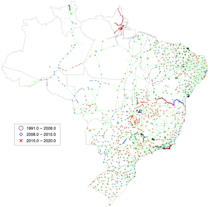
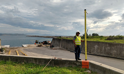
The generalized application of such strategy by the IBGE itself was hindered by difficulties to establish a suitable distribution of SAT GNSS connection stations in the SGB´s RRNNs - the so-called SAT-RN stations. In 2008, the IBGE began to carry out exclusive campaigns of GNSS in RRNNs, stepping them up from 2015 onwards with the GNSS Occupation campaigns in RRNNs (OGR), aiming at carrying out measurements in RRNNs located in the geographic “voids” established from a 50-km radius of the existing connections. As a result, it was possible to hit a minimally suitable distribution to begin the studies related to the improvement of the conversion of altitudes, as shown in the following picture:
Lastly, it should be highlighted that the improvement of the model of conversion of altitudes was also boosted by the release of the new normal altitudes, resulting from the Adjustment of the Altimetric Network with Geo-potential Numbers (REALT-2018). Besides better coupling with the terrestrial gravity field, that new set of altitudes also reflects the effects of an extensive debugging of the gaps of the entire altimetric network. In order to also benefit the GNSS users, a specific model to convert altitudes was required, reinforcing the reasons to develop the hgeoHNOR2020.
Justification
Currently, the technology preferably used for a precise spatial positioning is that of the GNSS. Depending on the type of receiver, collection time and calculation methodology, the coordinates and altitudes determined by GNSS surveyings might hit high precision, with uncertainties of few millimeters in relation to the ellipsoid of reference, leading to their adoption in a growing number of activities. Nevertheless, in the specific case of geometric altitudes, its use is quite restricted, due to their purely geometric nature, not reflecting the intrinsic link with the gravity field that the concept of altitude should have. In other words, the static water surface of a big lake materializes the concept of horizontal surface (equipotential surface of the gravity field), maintaining a constant value of physical altitude, but its geometric altitudes might change a lot, due to the previously mentioned decoupling of the ellipsoid in relation to the equipotential surfaces of the terrestrial gravity field.
In the SGB, physical altitudes were traditionally considered orthometric and obtained through high-precision geometric leveling, with reference to a vertical datum materialized from the mean sea level, considered a suitable proxy of the geoid by the classic methodology when the IBGE began this activity. The necessary conditions to characterize them as orthometric also included the existence of gravimetric information associated to the leveling stations. As the IBGE works of gravimetric densification began only in the 1980s, focused on the “gravimetric voids” of the National Territory, most of the SGB´s Altimetric Network, started in 1945, did not have any gravimetry associated to their RRNNs. Such difficulty was mitigated with the use of the theoretical gravity, also called normal gravity, in the calculation of the so-called orthometric-normal correction for each levelling section between successive RRNNs.
The typology of the altitudes of the SGB´s RRNNs changed for the first time in 2018, after REALT-2018, when they were calculated with corrections derived from the use of the real gravity observed through gravimetric surveyings directly in the RRNNs or in their surroundings - in contrast to the theoretical gravity, used in the previous adjustments. The use of this new type of correction follows international recommendations and results in the so-called normal altitudes. As a result, it is required to also update the tool that converts geometric altitudes resulting from GNSS surveyings, so that the resulting physical altitudes are compatible with the new implementation of the SGB´s vertical component, i.e., with the normal altitudes calculated in REALT-2018.
Model calculation
Normal altitudes (HN) from REALT-2018 and geometric altitudes (h) related to SIRGAS2000 were used, as well as geoid altitudes (N) extracted from MAPGEO2015, from 1,344 SAT-RN stations, for the calculation of the initial residues εo :

The procedure recommended by Forsberg and Tscherning (2008, “An overview manual for the GRAVSOFT Geodetic Gravity Field Modeling Programs”) and already used in other countries: application of the Modeling by Least Squares (CMQ) from punctual residues εo for the calculation of the regular grid of corrections ω to be added to the grid of the model used as a basis, as well as the respective grid of standard deviation σω. In the scope of this procedure, the correction calculated to each point in the grid reflects the characteristics of the residues of the stations in its surroundings, leading to the existence of non-null residues in each individual SAT-RN station:
To apply the CMQ, the program GEOGRID, the GRAVSOFT package and MAPGEO2015 were used as a basis model. A specific routine was implemented for the addition of grids (N+ω=η), recalculation and statistical analysis of the residues and the repetition of the entire process after a possible rejection of one or more stations.
The rejection of stations is based on the comparison among punctual residues recalculated (ε) and the respective estimates of uncertainty extracted from the grid of standard deviation of the corrections. Stations whose recalculated residues surpass the usual limit are rejected - the triple of the standard deviation of the respective correction (σω). In case of rejection, the calculation process is repeated.
Having the SGB´s SAT-RN stations as major input, hgeoHNOR2020 is less reliable as the distance among them increases. Therefore, in the westernmost area of Brazil, an area significantly far from the RAAP stations, MAPGEO2015 values were maintained. For this purpose, the grids of corrections and uncertainties related to Imbituba are truncated in this region, according to the following pictures.
Lastly, the grids of corrections related to Imbituba and Santana are added to the MAPGEO2015 grid, resulting in the grids of conversion factors η that comprise, together with the respective grids of uncertainties, the hgeoHNOR2020 model for conversion (next pictures). More details on the development of the model are shown in report.
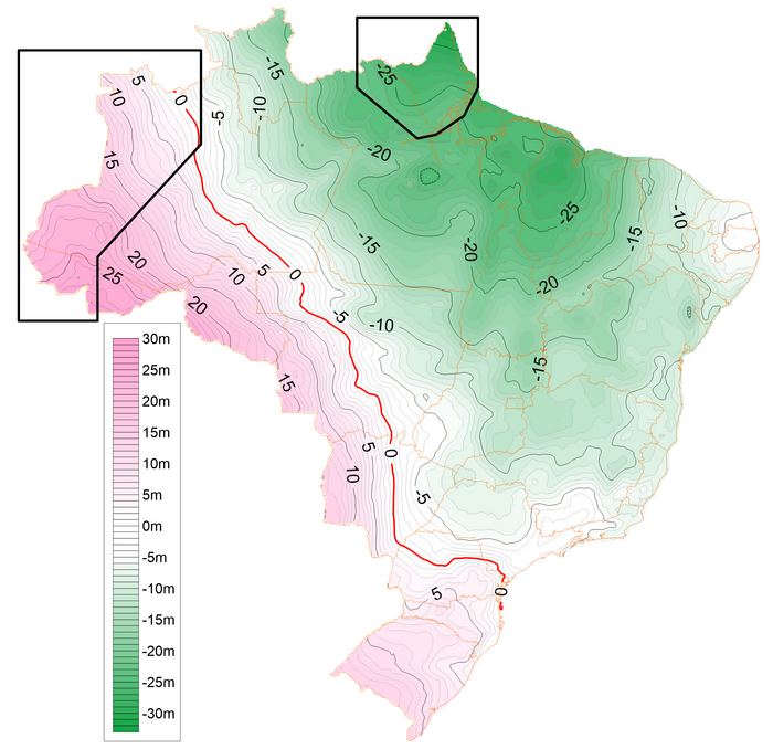
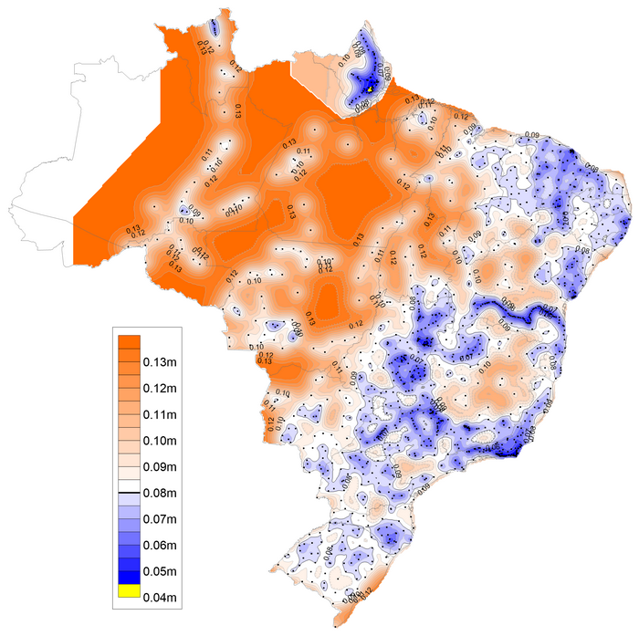
hgeoHNOR2020: curves of isovalues of the factor to convert geometric altitudes into normal altitudes.
hgeoHNOR2020: curves of isovalues of the standard deviation of the factor to convert geometric altitudes into normal altitudes.
Model assessment
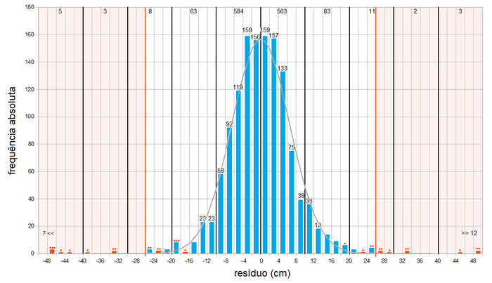
The methodology used leads to the existence of residues in all the stations used, which are taken into account in the assessment of the solution resulting from each iteration, repeating the process until no new rejections occur according to the criteria mentioned (ε>3σω). The histogram shown below represents the frequency distribution of the final residues, allowing to note that 85.3% of the stations have residues between ±10 cm and 95.2%, between ±18 cm. The blue bars represent the residues in stations used to calculate hgeoHNOR2020 and the red ones, those related to the rejected stations. The red dots represent the number of rejected stations.
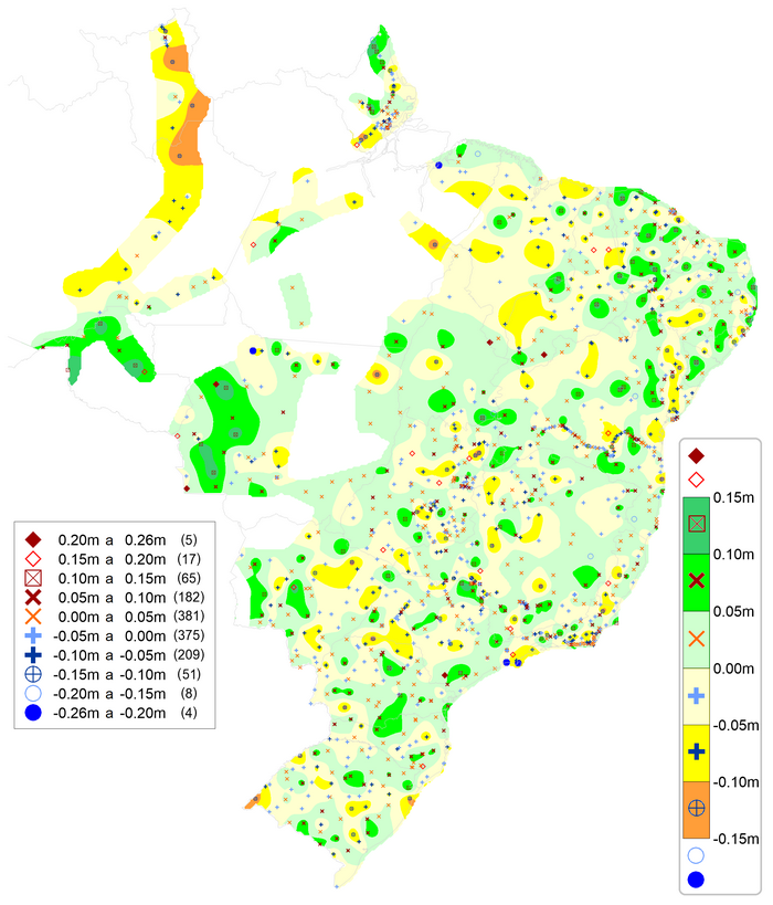
Considering only the 1,297 SAT-RN stations used in the final calculation, the root mean squared error of prediction (RMSEP) of the residues is 6.5 cm. The following cartogram shows the relative homogeneity in the spatial distribution of these stations, according to the different ranges of residues - except for the north-westernmost of Brazil, in which negative residues prevail in the states of Roraima and Amazonas, and positive ones in Rondônia and west of Mato Grosso. Considering only the 592 stations used in 2015 to assess MAPGEO2015 with RMSEP of 17 cm - from which three belong to the set of stations rejected in the calculation of hgeoHNOR2020 -, the RMSEP of the residues of hgeoHNOR2020 is 10.2 cm, confirming a better adherence of the hgeoHNOR2020 results to the altitudes of the SGB´s Altimetric Network.
The assessment of the global relative precision of hgeoHNOR2020 was accomplished through the calculation of the difference of residues in each pair of stations far up to 50 km. These individual results were grouped at each 1 km and the average difference in each group was used to produce the following graph.
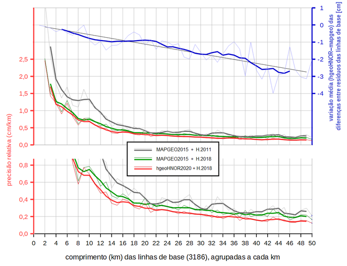
It can be noticed that, for 6-km distances, for example, the relative precision of hgeoHNOR2020 is 1.0 cm/km and, of MAPGEO2015, 1.4 cm/km and 1.06 cm/km, considering physical altitudes of 2011 and 2018, respectively. Between hgeoHNOR2020 and MAPGEO2015 (with normal altitudes), the blue lines represent the variation of the differences among the residues in each pair of stations - the variation is -0.4 cm for the same 6-km example. It can be noticed that the relative improvement in relation to MAPGEO2015 is steeper for smaller distances. It can also be noticed that, in contrast to the absolute results of MAPGEO2015 previously mentioned, the relative performance of MAPGEO2015 is significantly improved with the use of the normal altitudes of 2018.
News and Releases
Model to Convert Altitudes
New IBGE application to convert altitudes improves precision and accelerates calculations
The IBGE launches today (5) an application with a new model to convert altitudes, the hgeoHNOR2020. Besides...
05/08/2021
Errata
Calendar error in release of Annual set of Planialtimetric Stations (GNSS) grounded on measured and processed RRNN
Published date: 29/07/2022
Description:
Error characterized for not meeting the release date of the product, according to the calendar available in December 2021. The product was canceled due to logistic and operational difficulties concerning the restriction of on-site activities in the first quarter for servants, most of them aged over 60 years, which led to restrictions in the production and further need to readjust deadlines. Therefore, the release of the Annual set of Planialtimetric Stations (GNSS) grounded on measured and processed RRNN was postponed from 2022 to 2023.Actions: The release calendar has been changed.
Processar os dados
!!ATENÇÃO!!
Em 5 de agosto de 2021, o IBGE lançará o novo modelo hgeoHNOR2020, que propicia maior acurácia na conversão entre altitudes geométricas (GNSS) e altitudes normais (RRNN do SGB). Em decorrência disso, a página de cálculo de alturas geoidais com o MAPGEO2015 (“MAPGEO2015 online”) não mais estará disponível.