

Nossos serviços estão apresentando instabilidade no momento. Algumas informações podem não estar disponíveis.
-
Home

-
Geosciences
-
Territorial organization
-
Territorial Meshes
- NP-Mesh of Enumeration Areas
Mesh of Enumeration Areas
Description
It is a compilation, in digital format, of the smallest territorial portion used by IBGE to plan and carry out data collection for the Census and Statistical Surveys: the Enumeration Area. This corresponds to a section of the national territory, considering the Political-Administrative Division and other territorial structures, which allows the collection of statistical information within the due collection period.
It depicts the stage of IBGE's cadastral systems in time, according to the processes of data acquisition, treatment, management and updating, to be used in the construction of the Census Mapping for the Population Censuses and Household Surveys. It constitutes an overview of the Brazilian Political-Administrative Division in force on the reference date, including States, Federal District, Municipalities, Districts and Subdistricts, whose cadastral identification comprises the code of the enumeration area. In addition, each enumeration area brings information capable of organizing the collection, such as its urban or rural location/feature and status of locations, such as cities, villages, urban centers and rural agglomerations.
As of 2020, it became possible to distinguish the Mesh of Enumeration Area or, simply Census Mesh, from the new product, the Intermediate Mesh of Enumeration Area. The former is linked to the disclosure of the results of operations such as Population Censuses, Censuses of Agriculture and Population Count. In this case, as it is the result of a thorough survey of the Brazilian territory, it will have a much larger set of information than the Intermediate Mesh of Enumeration Areas. This, in turn, will bring annually updated information on territorial changes that affect the form and classification of enumeration areas on a annual basis, although it does not bring the statistical information brought by the former.
About the publication - 2010 Census Mesh
It is a set of files containing the polygons that define municipalities, districts, subdistricts, neighborhoods and enumeration areas.Therefore, it portrays the Political-Administrative Division of Brazil, through the vectors representing the defining lines of territorial borders in 2010.
Enumeration Area
The enumeration area control units made up of continuous polygons, entirely contained in urban or rural areas, whose size, number of households and establishments allow the enumerator to carry out his activities within a specified period, respecting the schedule of activities. The enumeration area is the work field of the enumerator.
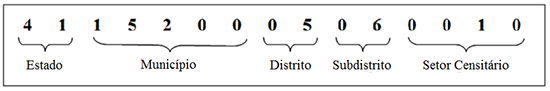
Each enumaeration areas has an identifying number, called a geocode. It is formed by recomposing the political-administrative hierarchy to which the enumeration area belongs: the first two digits refer to the state code; the subsequent five are related to the municipality; the next two indicate the district; the next two point to the subdistrict; and, finally, the last five to the enumeration area.

Criteria for delimiting enumeration areas
Enumeration areas are defined to guarantee the collection of census surveys and the dissemination of data by territorial sections. Thus, there are three basic rules for delimiting census sectors:
- minimum and maximum number of households or agricultural establishments: between 150 and 400 in urban areas and, for rural areas, between 150 and 250. As for agricultural establishments, the threshold is 100 to 200 for urban and rural areas.
- its limits should preferably be guided by recognizable elements in the landscape, facilitating the location of the enumerator in the field and allowing him/her to identify the households belonging to his work area;
- its limits must respect the political-administrative division and other territorial areas of data dissemination
Political-Administrative Division
The enumeration areas comply with the political-administrative divisions of the municipality, district and subdistrict. The district and subdistrict laws used to define the census sectors used to be forwarded to the IBGE y the municipal government until 2009.
Neighborhoods
The enumeration areas comply with, for the sake of operationality, the neighborhood laws that were forwarded by the municipal government until 2009 to IBGE. In some cases, there was no feasibility of applying the neighborhood laws to the Territorial Base due to cartographic inconsistencies or the operational logic of the census sector.
Classification of enumeration areas as Urban or Rural
From the point of view of the IBGE Census Mapping, it is necessary to differentiate between urban area and urban zone. The former, of a geographical nature, refers to the lived space, understood morphologically through analyzes and observations of the actual use of the soil and ways of life. The latter, of a political-administrative nature, refers to the legal delimitation for urban and tax policy purposes, which lie under the municipality's duties. The former is the de facto, while the second is the jure.
As the IBGE's mission is "To portray Brazil with information necessary for the knowledge of its reality and the exercise of citizenship", the Census Mapping, an instrument to support statistical surveys and censuses, seeks whenever possible to comply with the municipal legislation of urban policy (including Master Plans, Macro-Planning and Urban Perimeters) provided that such instruments are effectively forwarded to the Institute with their respective maps enclosed.
However, not all municipalities have such instruments and not all legislation is up to date with the urban expansion process that is observed in the field or through images. In such cases, the institute updates its mesh of enumeration areas also through the morphological criterion, valuing the space lived and observing the areas actually occupied for urban purposes, that is, lands smaller than the rural modules and actually built.
The classification of enumeration areas as urban or rural corroborates to the estimate of the urban and rural population.
Association with statistical data
The meshes of enumeration areas, using the Geographic Information System (GIS) software, can be associated with census statistical data, which are available in the file of Aggregation by Enumeration Area, of the Results of the Universe of the 2010 Population Census.
Classification of the enumeration area by status and type
In addition to the previously mentioned features, the enumeration areas are classified by status, in order to deepen and distinguish different categories of dispersion and agglomeration of households in the territory. This distinction aims at detailing the general classification of census sectors in urban or rural areas.
There is also a classification of enumeration areas by type, which identifies territorial structures that require differentiated logistical operations in the Census.
The status and type categories are explained in the 2010 Population Census Methodology (page 385, available at: https://loja.ibge.gov.br/metodologia-do-censo-demografico-2010.html). This classification can be accessed through the files of Agregados por Setor Censitário, Resultados do Universo do Censo Demográfico 2010 (Aggregation by Enumeration Areas, Results of the Universe of the 2010 Population Census .
More on the product - 2010 Census Mesh
Learn more - 2010 Census Mesh
Setor Censitário
O setor censitário é a unidade de controle cadastral formada por área contínua, integralmente contida em área urbana ou rural, cuja dimensão, número de domicílios e de estabelecimentos permitem ao recenseador cumprir suas atividades em um prazo determinado, respeitando o cronograma de atividades. O setor censitário é a área de trabalho do recenseador.
Cada setor censitário possui um número identificador, denominado geocódigo. É formado através da recomposição da hierarquia político-administrativa a qual o setor censitário pertence: os dois primeiros dígitos se referem ao código do estado; os cinco subsequentes se relacionam ao município; os dois seguintes indicam o distrito; os dois na sequência apontam o subdistrito; e, por fim, os cinco últimos ao setor censitário.
Critérios para delimitação dos setores censitários
Os setores censitários são definidos para garantir a coleta das pesquisas censitárias e a divulgação de dados por recortes territoriais. Assim, existem três regras básicas de delimitação dos setores censitários:
- número mínimo e máximo de domicílios ou estabelecimentos agropecuários: entre 150 e 400 nas áreas urbanas e, para as áreas rurais, entre 150 e 250. Quanto aos estabelecimentos agropecuários, o limiar é de 100 a 200 para áreas urbanas e rurais.
- seus limites devem, preferencialmente, ser pautados por elementos reconhecíveis na paisagem, facilitando a localização do recenseador em campo e permitindo que este identifique os domicílios pertencentes a sua área de trabalho;
- seus limites devem respeitar a divisão político-administrativa e demais recortes territoriais de divulgação dos dados
Divisão político-administrativa
Os setores censitários respeitam as divisões político-administrativas de município, distrito e subdistrito. As leis de distrito e subdistrito utilizadas para a definição dos setores censitários foram encaminhadas pelo poder público municipal ao IBGE até 2009.
Bairros
Os setores censitários respeitam, na medida da operacionalidade, as leis de bairros que foram encaminhadas pelo poder público municipal até o ano de 2009 ao IBGE. Em alguns casos, não houve viabilidade de aplicação das leis de bairros para a Base Territorial em virtude de inconsistências cartográficas ou da lógica operacional do setor censitário.
Classificação dos setores censitários em Urbanos e Rurais
Do ponto de vista da Base Territorial do IBGE, há que se diferenciar área urbana de zona urbana. A primeira, de caráter geográfico, refere-se ao espaço vivido, compreendido morfologicamente através de análises e observações do uso efetivo do solo e modos de vida. A segunda, de caráter político-administrativo, refere-se à delimitação legal para fins de política urbana e tributária, de competência do município. A primeira é o Estado de Fato, enquanto a segunda se refere ao Estado de Direito.
Como a missão do IBGE é "Retratar o Brasil com informações necessárias ao conhecimento de sua realidade e ao exercício da cidadania" a Base Territorial, instrumento de suporte às pesquisas estatísticas e censos, busca sempre que possível observar a legislação municipal de política urbana (incluindo Planos Diretores, Macrozoneamentos e Perímetros Urbanos) desde que tais instrumentos sejam efetivamente encaminhados ao Instituto acompanhados de seus respectivos mapas.
Contudo, nem todos os municípios possuem tais instrumentos e nem toda a legislação está atualizada face o processo de expansão urbana que se observa em campo ou através de imagens. Nesses casos o instituto atualiza sua malha de setores censitários também através do critério morfológico, valorizando o espaço vivido e observando as áreas efetivamente ocupada para fins urbanos, ou seja, terrenos de dimensões abaixo dos módulos de fracionamento rural e efetivamente edificados.
A classificação dos setores censitários em urbanos e rurais serve ao levantamento da população urbana e rural do país.
Associação com dados estatísticos
A malha de setores censitários, através dos softwares de Sistemas de Informação de Geográfica (SIG), pode ser associada aos dados estatísticos censitários, que estão disponíveis no arquivo referente aos Agregados por Setor Censitário, dos Resultados do Universo do Censo Demográfico 2010.
Classificação do setor censitário por situação e tipo
Além dos atributos já discutidos, os setores censitários são classificados por situação, de modo a aprofundar e distinguir diferentes categorias de dispersão e aglomeração de domicílios no território. Esta distinção objetiva o detalhamento da classificação geral dos setores censitários em urbanos ou rurais.
Existe também a classificação dos setores censitários por tipo, que identifica estruturas territoriais que possuem operação logística diferenciada no Censo.
As categorias de situação e tipo são explicitadas na Metodologia do Censo Demográfico 2010 (pag 385, disponível em: https://loja.ibge.gov.br/metodologia-do-censo-demografico-2010.html). Esta classificação pode ser acessada através dos arquivos de Agregados por Setor Censitário, Resultados do Universo do Censo Demográfico 2010.
News and Releases
IBGE launches Intermediate Sectoral Mesh 2021
The IBGE releases today (21) the Intermediate Sectoral Mesh 2021 in digital format, including the classification...
21/11/2022
IBGE discloses the 2020 Intermediate Mesh of Enumeration Areas
Today (25) the IBGE publishes the 2020 Intermediate Mesh of Enumeration Areas in digital format, with...
25/02/2021
IBGE launches Intermediate Sectoral Mesh 2019
The IBGE releases today (30) the Intermediate Sectoral Mesh 2019 in digital format, including the classification...
30/07/2020

Errata
Amendment in the release of the 2020 Intermediate Mesh of Enumeration Areas
Published date: 15/03/2021
Description:
Amendment in the release of the 2020 Intermediate Mesh of Enumeration Areas, published on February 25, after determining inconsistencies in the counting of enumeration areas, which were amended from 448,988 to 449,880.
Files in shape and kml format of the "2020 Intermediate Sectoral Mesh" were replaced to correct the field “Sub-district” in the Federal District and the field “District” in the Muncipalities of 2205706 - Luís Correia-PI; 2401305 - Campo Grande-RN; 2601607 - Belém do São Francisco-PE; 3122900 - Dona Euzébia-MG; 4216057 - São Cristóvão do Sul-SC; 4323770 – Westfália-RS; 5000203 - Água Clara-MS; 5001904 – Bataguassu-MS and 5220157 - São Luiz do Norte-GO.Actions: The news was updated at https://agenciadenoticias.ibge.gov.br/en/agencia-press-room/2185-news-agency/releases-en/30121-ibge-divulga-malha-setorial-intermediaria-2021.
The files were replaced at https://www.ibge.gov.br/en/geosciences/territorial-organization/territorial-organization/28114-malhas-de-setores-censitarios-divisoes-intramunicipais-2.html?=&t=o-que-e.
Links